
GPS Navigator Systems
FURUNO Electric Co., Ltd.
Refurbished
Manufacturer: FURUNO Electric Co., Ltd.
Country of Origin: Japan
Model: GP-150
Product Type: Marine GPS / DGPS Navigator
Marine Application: Position fixing, route navigation, waypoint management, speed/course monitoring and navigation-data output to other bridge equipment.
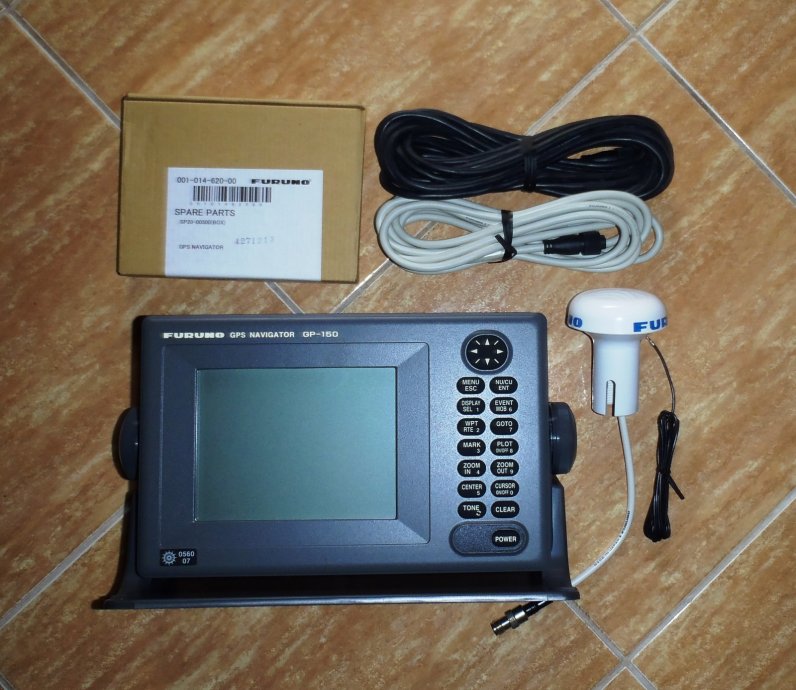
The supplied image shows a FURUNO GPS Navigator GP-150 display unit with antenna and associated cables, a configuration widely used aboard commercial vessels.
The FURUNO GP-150 is a commercial marine GPS navigator combining a GPS receiver with a monochrome navigation display and external antenna. It was designed to provide vessel position, course, speed, waypoint, route and track information while interfacing with other bridge equipment.
The GP-150 uses a 12-channel parallel GPS receiver and an 8-state Kalman filter for position, course and speed calculation. FURUNO's documentation specifies GPS, DGPS and WAAS operation, depending on configuration.
Although the GP-150 is now officially listed as no longer available, many commercial ships continue operating existing units, making compatible displays, antennas and spare parts relevant for maintenance.

The GP-150 is a dedicated shipboard GPS navigation receiver and video plotter. Once satellite position fixing is established, the navigator can provide essential information such as:
The unit can also output navigation information to compatible radar, autopilot, echo sounder and other shipboard systems through its digital interfaces. FURUNO specifies IEC 61162-1/NMEA 0183 connections for external equipment.
The GP-150 can simultaneously track up to 12 GPS satellites, providing continuous position calculation.
FURUNO specifies approximate accuracy figures of:
GPS: 10 m (2drms)
DGPS: 5 m (2drms)
WAAS: 3 m (2drms)
Actual performance depends on satellite geometry, signal environment and correction availability.
The GP-150 provides storage for:
999 waypoints
30 routes
2,000 track and mark points.
Available display modes include:
Plotter 1 – Plotter 2 – Highway – Navigation – Data.
The system supports alarms including:
*External sensor/data input is required for applicable functions.
The MOB function records the vessel's position when activated and provides continuous range and bearing information back to that location.
FURUNO's operator documentation specifies approximately 10 W power consumption.
The display unit contains the receiver electronics, operator controls and monochrome LCD.
The display measures approximately 122 × 92 mm with 320 × 240 pixels.
Navigation keys provide direct access to functions including MENU, DISPLAY, EVENT, GOTO, MARK, PLOT, ZOOM, CENTER, CURSOR and POWER.
Depending on system configuration, FURUNO documentation lists antenna options including:
GPA-018S – antenna with internal beacon receiver configuration
GPA-019S – DGPS-related antenna configuration
GPA-017S – antenna configuration without internal beacon receiver.
The exact antenna must always be matched against the vessel's existing GP-150 configuration before replacement.


The antenna cable carries the received GPS signal between the external antenna and navigator. Connector corrosion, damaged coaxial cable or poor termination can cause intermittent or complete loss of position fixing.
Depending on configuration, the GP-150 can work with DGPS correction data. FURUNO documentation identifies the GR-80 DGPS Beacon Receiver in relevant system configurations.
The GP-150 provides interfaces for exchanging navigation information with compatible equipment such as:
Radar – Autopilot – Echo Sounder – Computer – Other Navigation Equipment.
FURUNO specifies two IEC 61162-1/NMEA 0183 I/O connections, another IEC 61162-1/NMEA 0183 or log output, and a DGPS/PC interface.
| Specification | FURUNO GP-150 |
|---|---|
| GPS Frequency | 1575.42 MHz |
| Tracking | C/A Code |
| GPS Channels | 12 parallel |
| Position Update | 1 second |
| GPS Accuracy | Approx. 10 m (2drms) |
| DGPS Accuracy | Approx. 5 m (2drms) |
| WAAS Accuracy | Approx. 3 m (2drms) |
| Warm Start | Approx. 12 seconds typical |
| Cold Start | Approx. 90 seconds typical |
| Display | 122 × 92 mm monochrome LCD |
| Resolution | 320 × 240 |
| Waypoints | 999 |
| Routes | 30 + simplified route |
| Track/Marks | 2,000 points |
| Power Supply | 12/24 VDC |
| Position Update | 1 second |
Specifications are based on FURUNO technical documentation.
The FURUNO GP-150 has been installed aboard many types of commercial vessels, including cargo ships, bulk carriers, tankers, container ships, offshore vessels and other merchant ships.
Its primary function is dependable position fixing, but the GPS data may also feed other bridge equipment. This makes the GP-150 an important part of the vessel's wider navigation-data network.
Check the antenna first.
Inspect the antenna connector, coaxial cable, antenna installation and physical condition. Confirm that the antenna has an unobstructed view of the sky.
The GP-150 includes GPS monitor and diagnostic functions that should be checked before replacing hardware. FURUNO's operator manual contains dedicated GPS/DGPS error and diagnostic-test sections.
Common causes include:
Antenna deterioration → damaged coaxial cable → loose connector → moisture ingress → poor satellite visibility → receiver/interface fault.
Check signal levels on the GPS monitor screen.
Verify:
Do not assume LCD failure before confirming the power supply.
If the GP-150 itself has a valid position, investigate the data interface rather than the antenna.
Check:
NMEA/IEC output settings → output port → baud/data configuration → wiring polarity → receiving equipment configuration.
Check whether the vessel is receiving valid differential correction information and inspect the beacon receiver/antenna configuration.
Unexpected loss of stored data can indicate memory problems, improper clearing of memory or internal hardware issues. Important route information should be backed up according to vessel procedures.
Keep the display unit clean and protected from moisture. Avoid aggressive solvents on the LCD or control panel.
Regularly inspect the external GPS antenna for physical damage, corrosion and deterioration caused by UV exposure and weather.
Antenna connectors and cables should be checked carefully whenever satellite reception becomes unstable.
Verify GPS position against other available navigation references and periodically check navigation-data outputs to radar, ECDIS, AIS or other connected equipment.
FURUNO provides preventive-maintenance, troubleshooting, error-message and diagnostic-test procedures in the GP-150 operator documentation.
The GP-150 has been discontinued and FURUNO directs customers toward the newer GP-170 platform.
However, existing GP-150 installations remain relevant because replacing an established marine GPS may require changes to mounting, antenna arrangements, wiring and NMEA/IEC interfaces with other bridge systems.
For vessels where the existing configuration remains serviceable, replacing a compatible GP-150 display unit, antenna, cable or associated component can therefore be a practical maintenance solution.
No. FURUNO currently lists the GP150 as No Longer Available and points users toward the GP170.
It is a GPS navigator with DGPS capability depending on its antenna/beacon configuration. WAAS operation is also documented.
It uses 12 parallel GPS channels and can track 12 satellites simultaneously.
The GP-150 stores up to 999 waypoints.
It provides 30 routes, with up to 30 waypoints per route, plus a simplified route.
Yes. It provides IEC 61162-1/NMEA 0183 interfaces for compatible external navigation equipment.
FURUNO specifies 12 VDC or 24 VDC operation.
The FURUNO GP-150 GPS Navigator is a professional marine navigation receiver manufactured by FURUNO Electric Co., Ltd., Japan. It features a 12-channel GPS receiver, GPS/DGPS/WAAS positioning, 999-waypoint memory, 30 routes, track plotting, navigation alarms, MOB functionality and IEC 61162/NMEA interfaces for connection with other bridge equipment. The GP-150 is discontinued but remains installed on many existing commercial vessels.
Marine Automation & Navigation Equipment Supplier
Available Condition:
• New Equipment • Used Equipment • Refurbished Equipment • Reconditioned Equipment
Stock Location:
• Bangladesh • China
Services:
• Worldwide Shipping • Technical Support • Spare Parts Supply • Marine Equipment Sourcing
Contact Information
SM MARINE SERVICE™ Samir Market, DT Road, Pahartali, beside CDA Market, Chattogram, Bangladesh
Mobile / WhatsApp / Viber: +88 01818 929292
Email: info@smmarineservice.com
Website: www.smmarineservice.com
0
BDT 0
BDT 0
BDT 0
BDT 0
Marine Equipment Supplier