FURUNO SC-50 Satellite Compass
FURUNO
Refurbished
Manufacturer: FURUNO Electric Co., Ltd.
Country of Origin: Japan – FURUNO brand/origin; individual SC-50 components should be verified from their nameplates
Model: SC-50
Product Type: THD Satellite Compass / GPS-Based Heading Sensor
Display: 4.5-inch monochrome LCD
Power Supply: 12/24 VDC
Heading Accuracy: 0.8° RMS
Settling Time: Approximately 3 minutes
Marine Application: True heading, position, course/speed, rate-of-turn and vessel motion information for radar/ARPA, AIS, ECDIS and sonar systems.
FURUNO officially describes the SC-50 as a Satellite Compass developed using its GPS kinematic technology. The equipment has no traditional spinning gyro or gimballed compass mechanism and is designed to provide heading information to multiple bridge and navigation systems.

The FURUNO SC-50 Satellite Compass is a GPS-based true-heading and vessel-motion sensor developed for professional marine navigation.
Unlike a conventional magnetic compass, its heading calculation is not dependent on the Earth's magnetic field. Unlike a traditional gyrocompass, it does not rely on a high-speed spinning rotor.
Instead, the SC-50 determines heading using multiple GPS antennas and carrier-phase measurements. FURUNO specifically highlights that its performance is unaffected by geomagnetism, does not require the speed correction associated with a gyrocompass, and has no rotating motor or gimbals.
This makes the SC-50 particularly useful as a heading source for other shipboard electronics.
The SC-50 is more than a basic GPS receiver.
A conventional GPS receiver can determine vessel position, course over ground and speed over ground. However, COG is not the same as the vessel's actual heading, especially when a vessel is stationary, moving slowly, drifting sideways or operating in strong current.
The SC-50 uses a multi-antenna GPS arrangement and kinematic processing to determine the vessel's orientation and provide true heading.
It can therefore serve as a heading source for equipment such as:
FURUNO specifically identifies Radar/ARPA, AIS, ECDIS and scanning sonar among the intended heading applications.
The SC-50 uses FURUNO's GPS kinematic technology to calculate true heading without depending on geomagnetic heading.
Published specifications give the SC-50 a heading accuracy of approximately 0.8° RMS.
FURUNO specifies a settling time of approximately three minutes, allowing heading information to become available relatively quickly after startup.
There are no gimbals or rotating motors. This eliminates many mechanical wear points associated with conventional gyrocompasses and reduces routine mechanical maintenance.
The system can provide vessel motion information including roll and pitch, useful for compatible sonar and other marine systems.
SC-50 installations can distribute heading/navigation information to several external systems. Interfaces include IEC 61162/NMEA-type digital data and FURUNO AD-10 heading output, depending on the connected equipment and configuration.
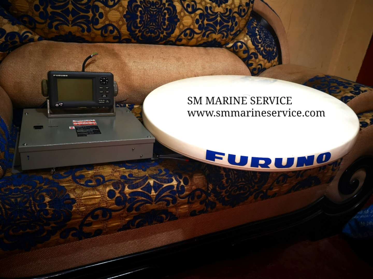
The dedicated SC-502 display provides heading and navigation information on a compact monochrome LCD. FURUNO lists the SC-50 display size as 4.5 inches.
The SC-50 is designed for standard shipboard 12 or 24 VDC electrical systems.
A complete SC-50 installation consists of several important components.
The large circular antenna assembly installed above deck contains the multi-antenna arrangement required for GPS-based heading determination.
The antenna location is extremely important. Obstructions, multipath reflections and interference can reduce GPS performance.
The SC-501 is the central processor of the SC-50 system.
It receives antenna signals, calculates heading and other navigation/motion information, and provides outputs for connected bridge equipment.
The processor also contains the external data connections required to distribute information throughout the vessel.
The compact SC-502 Display Unit allows bridge personnel to monitor heading and other available navigation information.
The display can present information such as:
Heading – Roll – Pitch – Position – Speed – Course – Navigation data, depending on display mode and configuration.
Correct antenna cabling is essential. Damaged connectors, corrosion, moisture ingress or excessive cable loss can result in unstable heading or complete loss of satellite tracking.
FURUNO's current SC-50 support information continues to list antenna-cable components among the system parts.
The FURUNO SC-50 can be used aboard merchant vessels, workboats, offshore vessels and other ships requiring reliable true-heading information.
Accurate heading data is critical for correct radar stabilization, target tracking and ARPA calculations.
AIS requires heading information to correctly transmit the vessel's reported heading to other ships and shore stations.
Heading information allows ECDIS to correctly orient vessel symbols and support integrated navigation functions.
Roll and pitch information can be valuable for stabilization and motion compensation in compatible sonar systems.
The SC-50 can provide heading, position and related navigation information as part of an integrated bridge system.
Possible causes include:
Check system alarms and antenna connections before replacing major components.
Possible causes include poor satellite visibility, antenna obstruction, multipath reflection, damaged antenna cables or incorrect installation parameters.
The antenna should have a clear view of the sky and be installed according to FURUNO's mounting requirements.
First verify the installation heading/offset settings.
A fixed error can often indicate incorrect alignment or configuration rather than a defective GPS heading calculation.
If the SC-50 display shows correct heading but radar, AIS or ECDIS does not, investigate the output interface rather than immediately replacing the antenna.
Check:
Check the SC-502 power/data connection and SC-501 processor supply.
If heading remains available to other bridge equipment while the display is blank, the fault may be isolated to the display or its connection.
Inspect the antenna environment for newly installed obstructions and check antenna cables/connectors for damage or water ingress.
Verify installation orientation, sensor settings and output configuration. Also determine whether the problem is present on the SC-50 itself or only on the connected sonar/navigation equipment.
One of the SC-50's major advantages is its lack of mechanically rotating compass components. FURUNO specifically notes that there are no gimbals or rotating motors requiring the routine mechanical maintenance associated with conventional gyro systems.
However, this does not mean the installation should be ignored.
Periodically:
Do not paint over the antenna or modify its mounting arrangement without checking the manufacturer's installation requirements.
The SC-50 is now a legacy product. FURUNO's current support page officially lists it as “No Longer Available” and directs customers toward newer models.
Nevertheless, many ships continue to maintain existing SC-50 installations.
The reason is straightforward: a satellite compass is often integrated with several other systems. A single SC-50 may supply heading to Radar/ARPA, AIS, ECDIS and sonar simultaneously.
Replacing the complete compass can therefore involve rewiring, interface conversion, configuration, bridge-equipment testing and commissioning.
For a serviceable existing installation, sourcing a tested SC-501 processor, SC-502 display, SC-303 antenna or compatible spare parts can therefore be a practical maintenance solution.
FURUNO also specifically notes that its newer SC-70 can be retrofitted using existing cabling from systems including the SC-50, SC-55, SC-60, SC-110 and SC-120 when the appropriate conversion kit is used.
The SC-50 is a GPS-based Satellite Compass designed to provide accurate true-heading and navigation information to shipboard systems.
No. It provides true-heading information using GPS kinematic technology rather than a mechanically spinning gyro.
FURUNO specifies approximately 0.8° RMS.
FURUNO states a settling time of approximately three minutes.
SC-501 is the processor unit used in the SC-50 system.
SC-502 is the dedicated display unit associated with the SC-50.
Yes. FURUNO specifically identifies the SC-50 for use as a heading sensor for Radar/ARPA, AIS, ECDIS and scanning sonar.
No. FURUNO currently lists the SC-50 as No Longer Available.
FURUNO's support page directs SC-50 users toward the SC-70 Satellite Compass.
FURUNO SC-50 Satellite Compass is a professional GPS-based marine heading system using FURUNO kinematic GPS technology to provide reliable true heading and vessel navigation/motion information. Major system components include the SC-303 antenna, SC-501 processor and SC-502 display unit. The SC-50 is suitable as a heading source for Radar/ARPA, AIS, ECDIS, sonar and other compatible marine navigation systems.
Marine Automation & Navigation Equipment Supplier
Available Condition:
• New Equipment • Used Equipment • Refurbished Equipment • Reconditioned Equipment
Stock Location:
• Bangladesh • China
Services:
• Worldwide Shipping • Technical Support • Spare Parts Supply • Marine Equipment Sourcing
Contact Information
SM MARINE SERVICE™ Samir Market, DT Road, Pahartali, beside CDA Market, Chattogram, Bangladesh
Mobile / WhatsApp / Viber: +88 01818 929292
Email: info@smmarineservice.com
Website: www.smmarineservice.com
0
BDT 0
BDT 0
BDT 0
BDT 0
Marine Equipment Supplier